Isophreatic curves of groundwater wells in the upper zone of Cerro de Hula, Santa Ana, Francisco Morazán
Authors
-
Kelly Almendares-Rivera
Master's in Water Resources with a Focus on Hydrogeology/ Universidad Nacional Autónoma de Honduras/Tegucigalpa/Honduras. 2 Water Resources Unit, Honduran Institute of Earth Sciences (IHCIT in Spanish) / Universidad Nacional Autónoma de Honduras/Tegucigalpa/Honduras
 https://orcid.org/0000-0003-0093-1385
-
Tania Peña-Paz
Experimental and Innovation Center for Water Resources (CEIRH-IHCIT in Spanish), Master's in Water Resources Coordination - Universidad Nacional Autónoma de Honduras
https://orcid.org/0000-0001-9685-5107
DOI:
https://doi.org/10.70099/BJ/2024.01.01.33Keywords:
groundwater, water table, isophreatic curves, radial flowAbstract
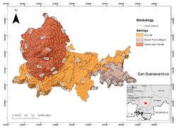
The research is part of a master's research thesis, the aim of which is the generation of groundwater well curves in Cerro de Hula, located south of the capital of Honduras, which serves as a baseline to understand the movement of groundwater flow in the area preliminarily. To achieve this, groundwater level surveys were carried out in the field in April 2022 (dry season), which were analyzed, processed, and interpolated using the Kriging method in ArcGis software. The main findings show the survey of 21 groundwater extraction points, belonging to shallow and deep wells that supply around 2900 people in the area, and that the preliminary water movement according to the isophreatic curves corresponds to a radial flow, with curves ranging from 5 m deep of the water table remaining in the western part of the area (highest part), and moving downwards to the 100 m deep curves (eastern region). It is conclusive to mention that this is a preliminary tool for managing the area's underground water resources.
References
1. INE. Instituto Nacional de Estadistica Honduras . Obtenido de INE: http://181.115.7.199/binhnd/RpWebEngine.exe/Portal?BASE=MUNDEP08&lang=ESP (2022).
2. ICF. Geoportal del Sector Forestal de Honduras. Obtenido de http://www.geoportal.icf.gob.hn/geoportal/main (2022).
3. IHCIT-UNAH. Evaluación de los Recursos Hídricos en su Régimen Natural. Tegucigalpa. (2014).
4. Ruiz, M.. Geología del área de influencia de los municipios de: Santa Ana, Ojojona y San Buenaventura. UNAH, Instituto Hondureño de Ciencias de la Tierra, Tegucigalpa. (2015).
5. Harwood, R. Geology of Ojojona Quadrangle. Instituto Geográfico Nacional y Dirección General de Minas e Hidrocarburos, Tegucigalpa, Honduras. (1991).
6. Anderson, M.. Geology of Lepaterique Quadrangle. Instituto Cartografico Nacional, Tegucigalpa, Honduras. (1985).
7. Rogers, R. O.. Geología del Cuadrangulo de Tegucigalpa, Francisco Morazán. Instituto Cartográfico Nacional, Tegucigalpa, Honduras. (1993).
8. Simmons, C. S.. Los Suelos de Honduras. Organizacion de las Naciones Unidas para la Agricultura y la Alimentación (FAO), Roma. (1969).
9. SINIT. Sistema Nacional de Información Territorial de Honduras. Obtenido de http://www.sinit.hn/ (2022).
10. Cruz, V. H., Galindo, K., Vásquez, C., & Edwar.. Plan de Desarrollo Municipal - Municipio de Santa Ana Francisco Morazán. Municipalidad de Santa Ana, Unidad Técnica Municipal, Santa Ana, Francisco Morazán. (2020). Obtenido de https://www.sgjd.gob.hn/biblioteca-virtual/docspdm/pdm-certificados/fco-morazan-pdm-certificados/1207-pdm-santa-ana-francisco-morazan/file
11. Municipalidad de Santa Ana.. Informe Levantamiento Línea Base Municipio de Santa Ana, Francisco Morazán. Santa Ana, Francisco Morazán. (2018). Obtenido de https://www.sgjd.gob.hn/biblioteca-virtual/docspdm/linea-base/08-francisco-morazan/1475-linea-base-santa-ana-francisco-morazan/file
12. Heraldo, E.. La zona sur de la capital se perfila como el nuevo polo de desarrollo. El Heraldo. Obtenido de https://www.elheraldo.hn/tegucigalpa/zona-sur-tegucigalpa-desarrollo-honduras-LXEH1465097#image-1. (2021).
13. Villatoro, M., Henríquez, C., & Sancho, F.. Comparación de los interpoladores idw y kriging en la variación espacial de ph, ca, cice y p del suelo. Agronomía Costarricense, 2008. 32(1), 95-105. Obtenido de https://revistas.ucr.ac.cr/index.php/agrocost/article/view/6773
14. Zucarelli, A., Paris, M., & Macor, J.. Utilización de kriging para la elaboración de curvas isohietas de precipitación mensual en la Provincia de Santa Fe, Argentina. Universidad Nacional del Litoral, Facultad de Ingeniería en Ciencias Hídricas, Santa Fé, Argentina. (2014). Obtenido de http://www.tvdigitalargen.ina.gov.ar/ifrh-2014/Eje3/3.39.pdf
15. Hughes, J., & Lettenmaier, D.. Data Requirements for Kriging: Estimation and Network Design. Water Resources Research, 1981. 17(6), 1641-1650. doi: https://doi.org/10.1029/WR017i006p01641
16. Rouhani, S., & Hall, T. J.. Geostatistical Schemes for Groundwater Sampling. Journal of Hydrology, 1988. 103, 85-102. doi: https://doi.org/10.1016/0022-1694(88)90007-8
17. Rouhani, S.. Geostatistics in Water Resources. Georgia Water Resources Conference. Georgia. (1989). Obtenido de https://repository.gatech.edu/server/api/core/bitstreams/e66fc3cd-6b12-4e20-af07-69a98da79499/content
18. Kitanidis, P. K.. Introduction to Geostatistics: : Applications in Hydrogeology. Stanford, California, EUA. 1997. Obtenido de https://books.google.es/books?hl=es&lr=&id=ZvoibTTS9QwC&oi=fnd&pg=PR19&dq=Introduction+to+Geostatistics+P.+K.+KITANIDIS&ots=q7BwBHFQqV&sig=9Fy-vSPhmDW_-OHUMROL40RMyNE#v=onepage&q=Introduction%20to%20Geostatistics%20P.%20K.%20KITANIDIS&f=false
19. Mejía Rivera, O., Betancur Vargas, T., & Londoño Ciro, L.. Aplicación de técnicas geoestadisticas en la hidrogeología del bajo Cauca Antioqueño. SciELO Analytics, 2007. 74(152), 137-149. Obtenido de http://www.scielo.org.co/scielo.php?script=sci_arttext&pid=S0012-73532007000200012
20. Gaspari, F. J., & Delgado, M. I.. Caracterización morfométrica geoespacial. Estudio de caso: Arroyo Belisario, Argentina. Tecnociencia Chichuahua, 2010. 4(3), 154-163. doi: https://doi.org/10.54167/tch.v4i3.711
21. Solinst, C.. Solinst Canada Ltd. Obtenido de Solinst Canada Ltd: https://www.solinst.com/espanol/productos/instrumentos-de-medicion-de-nivel/101-medidor-de-niveles-de-agua/ficha-tecnica/?utm_source=GA-&utm_medium=Search-&utm_campaign=101-GA-101-search-sa&utm_term=LM-SA-&utm_content=responsivetextad-spanish1&gad=1&gclid. (2023).
22. Barrera-de-Calderón, M., Garfias, J., Martel, R., & Salas-García, J.. Controles geológicos en el flujo de agua subterránea y distribución de volúmenes de extracción asociados a una estructura volcánica compleja. Boletín de la Sociedad Geológica Mexicana, 2021. 73(1), A170820 doi: https://doi.org/10.18268/BSGM2021v73n1a170820
23. Ruffo, A. G., Albouy, R., Giorgi, J., & Bastianelli, N.. El agua subterránea para abastecimiento humano en las dunas costeras del suroeste bonaerense. I Jornadas del agua en el Sudoeste Bonaerense, (págs. 293-296). Bahía Blanca, Argentina. (2019). Obtenido de https://www.researchgate.net/publication/338047277_El_agua_subterranea_para_abastecimiento_humano_en_las_dunas_costeras_del_suroeste_bonaerense
24. Gastmans, D., Veroslavsky, G., Kiang Chang, H., Caetano-Chang, M. R., & Nogueira Pressinotti, M. M.. Modelo hidrogeológico conceptual del Sistema Acuífero Guaraní (SAG): una herramienta para la gestión. Boletín Geológico y Minero, 2012. 123(3), 249-265. Obtenido de https://www.igme.es/boletin/2012/123_3/8_ARTICULO%204.pdf
25. Barrera de Calderón, M. L., Garfias, J., Martel, R., & Salas Garcia, J.. Influencia potencial de las fallas en el flujo de agua subterránea de un acuífero volcánico conformado por materiales porosos y fracturados. (T. y. agua, Ed.) Repositorio Institucional Universidad Autónoma del Estado de México. (2020). Obtenido de http://ri.uaemex.mx/handle/20.500.11799/106013
26. Auge, M.. Hydrogeology of Plains. Buenos Aires, Argentina: Springer. (2016). Obtenido de https://www.bfa.fcnym.unlp.edu.ar/id/42552
27. Enemark, T., Peeters, L., Mallants, D., & Batelaan, O.. Hydrogeological conceptual model building and testing: A review. Journal of Hydrology, 2018. 569, 310-329. https://doi.org/10.1016/j.jhydrol.2018.12.007
28. Mira, A., Vives, L., Rodríguez, L., & Veroslavsky, G.. Modelo hidrogeológico conceptual y numérico del Sistema Acuífero Guaraní (Argentina, Brasil, Paraguay y Uruguay). Sociedad Geológica de España-Geogaceta, 2018. 64, 67-70. Obtenido de https://sge.usal.es/archivos/geogacetas/geo64/geo64_17.pdf
Published
How to Cite
Issue
Section
Categories
License

This work is licensed under a Creative Commons Attribution 4.0 International License.
Authors who publish with BioNatura Journal agree to the following terms: Authors retain copyright and grant the BioNatura Institutional Publishing Consortium (BIPC) right of first publication with the work simultaneously licensed under a Creative Commons Attribution 4.0 International License (CC BY 4.0). This allows others to share the work with an acknowledgment of the work's authorship and initial publication in this journal.This is an open access article distributed under the terms of the Creative Commons Attribution 4.0 International License (CC BY 4.0), which permits unrestricted use, distribution, and reproduction in any medium, provided the original work is properly cited.

